Friday, November 25, 2011

Update Time!!

So it is the day after Thanksgiving, a little over a week left in the expedition. The Thanksgiving feast definitely lived up to expectations, the food on this boat has probably been the highlight of the trip so far. I would put the quality of this food up against just about any restaurant I’ve ever been to, I’m truly impressed with what the cooks can do on a ship. We have done 18 dredges now and still no metal sulfides (except for the tiny piece with pyrite on it) to make the Nautilus folks happy. The lavas have ranged from rhyolite pumice, which we haven’t seen much of since the first few dredges that were very close to the arc volcanic front, to the boninites that we saw early on, and more recently we have seen dacite, some of it very fresh, possibly erupted within the last few years, and even some basaltic andesite. The continuum of lava compositions based on silica composition is basalt (at the low end), andesite (intermediate), and rhyolite (high silica). It is MUCH more complicated than that, but those are the big three that you would learn in a basic geology class. Dacite falls between andesite and rhyolite, so it is a relatively high silica lava, and the stuff that we found was very glassy (cooled quickly) for the most part, almost like obsidian. We may have found some basaltic andesite in the last dredge since we are now dredging the Fonualei spreading center, significantly further from the arc and the influence of water in the mantle, which tends to create higher silica lavas. The only truly unique material was the previously mentioned sulfur.

A cool texture from the underside of a basalt sample. This texture forms on the underside of the roof of the lava flow from the lava dripping when the molten material drains out quickly.


A really cool example of basalt. The right side (black layer) is the glassy top of the lava flow, getting deeper toward the left, where a huge number of green olivine and clinpyroxene crystals have accumulated by settling toward the base of the lava flow.

I know I had said in this post that we hadn't found sulfides, but we finally did find some in a later dredge. They're hard to see in this pic but the darker gray stuff toward the interior is Galena (lead sulfide), and there is a tiny amount of copper and zinc sulfide in some of the samples. It actually looks cooler with a hand lens when you can see all of the individual crystals.

Supposedly in the latest AUV survey, they were able to identify some hydrothermal chimneys, so the next dredge in a few hours may actually find some sulfides or at least some hydrothermally-altered rocks, and perhaps some more deep sea critters. However, as I’ve mentioned it’s very difficult to target a small patch of seafloor with a dredge, so we may yet strike out on sulfides. I’m sure the critters will appreciate it if we miss the hydrothermal vent with the dredge. Apparently an ROV is a much better tool to sample hydrothermal vents, since it can be remotely controlled by someone from the ship and has video capability so they can see exactly what they are sampling. The AUV is really just a small-scale mapping tool that may tell them where the vents are located, but it sounds like it would be ideal to have both and AUV and ROV to really locate and sample the hydrothermal materials. Since Ken is not particularly interested in sulfides, he’s been pretty happy with all of the lavas that we’ve found, and hopefully once he analyzes the lavas back at UH, I will ultimately be able to correlate some of his findings with my own observations on the morphology and structure of the spreading centers. Fernando has also gotten them to sneak in a little mapping here and there on transits to various AUV sites to fill in some of the gaps in the bathymetry maps of the area, so that data will be directly useful for my PhD work. We still have some delays with the AUV, although it seems that most of the instrument/software problems are pretty much resolved by now. The problem is that these types of issues should have been resolved before the AUV was ever taken out to sea. We have lost a few days of valuable ship time with all of the AUV issues, something that no one is happy about. Apparently this particular AUV has not been used on a full science mission before and it seems that the crew in charge of it is not particularly experienced or competent, which has exacerbated the problems. They also refuse to deploy the AUV in even slightly rough seas and they won’t deploy at night, so it forces everyone to work around their schedule. I think it’s safe to say that Nautilus will not be using a Geomar AUV in the future. Nautilus is also the first company to use these methods for hydrothermal exploration, so we are essentially testing a whole new methodology for this type of work, which is also the cause of many of the delays and scheduling issues. The TowCam has had a few issues as well, but the dredging has had no problems at all. I guess it’s not surprising that the most low-tech instrument has the least number of problems. The TowCam has come up with some pretty cool photos though, including hydrothermal cracks and mounds on the seafloor, interesting pillow lava structures, huge beds of mussels surrounding hydrothermal vents, shrimp, crabs, fish, branchy and whip corals, crinoids (animals that look like flowers attached to the seafloor), and even an eel that was hiding from the cam under a rock. I’ll try to post a few of these, but with this brutally slow internet connection it’s going to be very difficult. I still want to post a few pics of Samoa too, but it literally takes 10-20+ minutes to upload one photo and sometimes it has an error during the upload and just doesn’t work. The internet connection has been a constant source of frustration.


A beautiful sunset through the A-frame on the aft (rear) deck of the ship. This is the structure that the winch controlling the dredge is routed through.

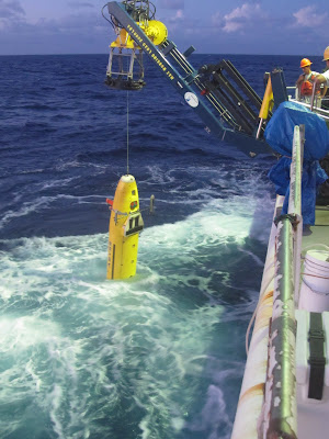
AUV deployment in action!

Last night, I spent some time out on the upper deck by the bridge listening to some Bonobo (perfect star-watching music) and enjoying some fresh air. There was a beautiful view of the stars and it was refreshing to feel the wind whipping against me, I think I’m going to do that just about every night for the rest of the cruise. I saw a couple shooting stars and even a few flashes of lightning way off in the distance. But, as with my experience on the Langseth previously, the star-viewing is still not as good as I’ve seen out in the mountains of California. Even though there are only a few lights on the ship, it is enough to spoil what should be a perfect view of the night sky. I’ll try to get in at least one more update before the end of the cruise, but that’s all for now…

Thursday, November 17, 2011

Update after a week

It is now Thursday 11/17, and we have completed 10 dredges. At this point I think I can safely safe that I’ve had my fill of dredging, for life. We’ve seen some interesting rocks, but you can only get excited about black lava rocks with varying amount of crystal and bubble content for so long. The most unique rocks that we recovered were almost pure sulfur. We actually dredged over a molten sulfur pond, which we could see stuck to the outside of the dredge bag. We also saw samples that appeared to be from the surface of the sulfur pond which had frozen “ripples.” There were also some really cool sulfur crystals, which I grabbed some take home samples of, as well as some sulfur spherules (basically small round globs of sulfur). Beyond that, most of the dredges after the first three, which were largely pumice, have been boninite lavas. To the non-geologist, they basically look like dark gray to black lava rock, and you really have to be a geochemist or petrologist to get excited about the variety within those. The most interesting examples of those rocks were some with very large crystals of olivine and pyroxenes, which I also grabbed some personal samples of. The only metal sulfides we have found, which is what Nautilus is interested in, were a couple tiny pieces with even tinier crystals of pyrite (fool’s gold), which is iron sulfide. Even though they have been trying to target the hydrothermal sites where the metal sulfides should be found, it is very difficult to target a specific area of seafloor with the dredge. We also dredged up a few deep sea creatures, including fragments of mussels, shrimp, coral, a crab, and even an eel-like fish. Thankfully we didn’t massacre too much life (only 7 or 8 creatures total), it is definitely an ethical issue that the non-Nautilus scientists are concerned about. We are freezing all of the life we find to give to a biologist for analysis. The process of deploying and retrieving the dredge, getting the samples out of the bag and organizing them in the lab has definitely lost its luster at this point. I end up absolutely drenched with sweat after every dredge, especially during the day, so I’ve had to get used to feeling disgusting most of the time. My personal favorite part, which the crew and other scientists gladly let me take care of, is beating the crap out of the dredge bag with a sledge hammer to knock all of the samples loose. It’s a nice aggression release and a pretty good workout too. It’s also fun working with Ken, who has a never-ending supply of stories about past cruise experiences and people that he has worked with, as well as gossip on people in the department. He is not one to hold his opinions back, and is a good source of entertainment and information about rocks and all things geochemical. One annoying part about the dredging is that we are doing a LOT more of it than we initially were supposed to be doing. The initial plan was to do ~1 dredge per 24 hours, which would be a pretty relaxed schedule and would give us plenty of time to process and analyze the samples between dredges, as well as plenty of time to sleep. Instead we have been doing at least 2 dredges per 24 hours, and the schedule has not been regular at all. They tried to get us to do 3 yesterday, which would have given us a window of about 5 hours to sleep, but we drew the line at that. Part of the problem is that they have been having pretty much non-stop issues with the AUV. It has been routinely coming up to the surface before finishing its survey, which means that they have extra time to fill, and that means we get to fill the time with dredging. It has also had problems with the battery not lasting long enough, and the latest thing is the multibeam bathymetry system went out, which is the primary mapping instrument that they wanted to use. Also, the AUV people have complained their way into getting a shorter shift, and the TowCam people have refused to work more than 12 hours in a day, so since I guess we are the bottom of the hierarchy, we get stuck filling the time with dredging. We have held the line at two dredges a day, but it is frustrating for all of us involved with the dredging that we are being treated as the low end of the totem pole. It is also frustrating that the schedule changes all the time, usually due to problems with the AUV or TowCam, and often without much warning. For instance, this morning, the schedule was filled up (with no dredging) until at least noon, so we figured we’d be dredging by 1 or 2 pm at the earliest. Instead, at about 9:30 am, someone came into my room to tell me we were about to start dredging. Thankfully, I had gotten enough sleep already, but it was pretty annoying regardless. Just about everyone is getting frustrated with Peter, the head of the Nautilus operation, partially because of the last minute scheduling changes and also because he is not providing the crew with timely and adequate information about where the various operations are going to be located. With all of that said, it’s impossible to expect that everything is going to go smoothly, so we’re making it work. At least the food is still delicious.


Sulfur!!! The ones with the ripples are from the top of the molten sulfur lake, the large ones on top have some nice crystals, and the tiny grayish ones on bottom are the spherules


A relatively fresh piece of boninite with a nice big clinopyroxene crystal in the middle.

Monday, November 14, 2011

Environmental Impact

There is a significant environmental issue with mining (and to a lesser extent dredging) active hydrothermal vents. There are a number of marine creatures that depend on the heat and the minerals ejected from these vents to survive. Bacteria feed on the sulfur and other minerals in the events, plankton and other small critters feed on the bacteria, then tube worms, corals, shrimp, crabs, mussels, and a variety of larger creatures feed on the bacteria and plankton. Each vent hosts a unique variety of creatures, and some of the creatures that have been identified exist literally nowhere else on earth but the single vent site where they were found. Pretty much every time a biologist studies one of these vent sites there are at least a few new species discovered. So it’s not hard to imagine that ripping up the rocks and hydrothermal chimneys at these vent sites would interrupt if not completely massacre these unique ecosystems. Dredging is unlikely to have as large of an effect because it wouldn’t destroy the whole site and it would most likely recover over a matter of months to years. But mining the area in the way that Nautilus plans to would likely cause irreparable damage to these delicate sites. The good news is that these vents typically only have a natural life span of a few years to maybe a few hundred years, but it’s impossible to predict when they will shut down. As I see it, the “holy grail” for this type of seafloor mining would be a way to reliably identify recently inactive vents which have already died on their own, but this is very difficult to do, because the easiest way to detect them is by the temperature and water column anomalies discussed previously, and those disappear once the vent dies. If we could reliably find dead sites there would be basically no negative environmental impact, but it is difficult to do. The hydrothermal activity alters the rocks, changing both the magnetic and gravity signatures, so these are potential methods for identifying dead vents, but you would have to have pretty high resolution data to find an individual hydrothermal field, and you would have to have some idea of where to look. Another problem with dead vents is that they are quickly buried by sediment, so unless the vents are recently inactive they would have to dig through meters to kilometers of sediment to get to the metals. As of now, they have not actually started mining any vents, and the Nautilus people are aware of the issue, but I doubt the environmental impact alone will stop them when they get to the mining phase.
A crack on the seafloor where hydrothermal fluids are released and mussels live

A picture from the TowCam, showing deep water corals and even a couple crabs

Some less fortunate shrimp that went for a ride in the dredge bag

The Operation

The survey sites were chosen based on previous data collected in the water column. Hydrothermal plumes produce a temperature anomaly in the water that can be detected down to less than 1/10 of a degree. Also, since they are spitting out water that is laden with particles and metals, the “cloudiness” of the water can also be detected and indicate that a hydrothermal vent is nearby. Chemical sensors can also detect the chemical anomalies in the water. There are various instruments that are attached to tow cables to detect these anomalies in the water column and give us an idea of where to look for the hydrothermal vents. Since these methods are much faster and can cover a large area, they are usually the first means of figuring out roughly where the vents are located. This kind of data was previously collected all over the survey area to give us an idea of where to look in more detail. The ideal order of operations for us is as follows:

1) Place two transponders on the seafloor in the vicinity of a known water column anomaly. These transponders tell the ship where the AUV is and also tells the AUV where it is, so the data can be properly located on a map. The ship uses GPS to determine its position, but GPS does not work under the ocean, so the transponders are the only way for the AUV to know where it is located and survey the desired area. This process takes ~6 hours.

2) Deploy the AUV. There is a special launching structure that was bolted to the rear deck of the ship that lifts the AUV over the edge and drops it in the water. Deploying takes 30 min to an hour if all goes smoothly.

3) AUV mapping. The AUV then goes down to the survey area and maps the area on its own, then returns to the surface and sends the boat a signal to let us know to pick it up. The AUV mapping takes ~6-12+ hours depending on whether it stays down as long as it's supposed to.

4) Place next two transponders. Ideally, while the AUV is surveying the first area we will place transponders at the next area so it is all ready to go once the AUV gets to the surface.

5) Camera Tow. Ideally, we should have the data from the first AUV survey and then would tow the camera over this same area to get a better idea of the materials that are in the survey area. This step can be interchanged with the next step, dredging, if the AUV map is not quite ready.

6) Dredging. Hopefully, we have seen some hydrothermal chimneys in the AUV data and confirmed their existence with the camera tows. Then we dredge the area to collect some samples. While lava rocks are fine for the geochemists and are useful to tell us about the nature of the area, the Nautilus people are by far most interested in hydrothermally-derived rocks that contain economically valuable metals. We have not recovered any of these rocks from the first four dredges, but we undoubtedly will once we can actually target the dredges at actual known hydrothermal vent sites. The first four dredges have been mostly “blind” since we have not had the AUV data to help us know where to dredge. Hopefully, for the fifth dredge and beyond, we will have better luck.

While the above procedure is the ideal order of operations, it still has not happened according to plan once. We have had a number of issues, including the winch being wound up improperly, the AUV having difficulty contacting the transponders and aborting as soon as it got in the water, and the line used to retrieve the AUV getting caught in the propeller. There have been some technical difficulties with the TowCam and the AUV as well, but it seems that we have pretty much gotten those ironed out. One problem with the schedule being so unpredictable is that it screws up everyone’s sleep schedules, since we can’t really rely on things happening when they are supposed to. We have all had some very long days because of this unpredictability, but hopefully in the future we will be able to get on a somewhat regular schedule.

Post rock-sawing photo. The sawing was very messy for most of the cruise, and then we found out that it was because the blade was spinning the wrong way and blasting all of the water and rock bits up at us instead of down. Probably should have figured that one out sooner.

The First Few Days

The schedule for the first few days of the cruise was thrown off a little because the AUV was delayed coming into Apia. We got on board on Tues 11/8, but instead of sitting around in port and waiting for it to arrive, we decided to go out to sea for two days and get some mapping, so we didn’t waste any precious and expensive ship time. We transited about 12 hours to the south to a site that was not extremely critical to the Nautilus people, and did 2 camera tows and 3 dredges. We were looking at 2 volcanoes that are very near the volcanic arc, where the lavas have a high water content. This has a number of effects, but two primary ones are that it causes many explosive eruptions and the lavas have a higher silica (SiO2, aka glass) content than those erupted along spreading centers. The explosive eruptions are caused by water and other gases in the magma expanding extremely quickly once they reach the seafloor. Within the magma chamber and the conduit through the crust, the pressure is very high, keeping the bubbles very small, but once that pressure is released, the bubbles expand extremely quickly, which causes the magma to fragment and explode instead of calmly flowing out of the vent. The high silica content also causes the magma to be more viscous, so that it more effectively traps the gases and they can’t just escape as a plume of volcanic gas. Silica content is the primary factor that determines whether an eruption will be explosive (like Mt. St. Helens, Krakatau, or Pinatubo), or effusive (like Kilauea on the Big Island in Hawaii, where the lava flows out relatively calmly over the surface and rarely explodes). That’s why it’s relatively safe to walk around near the lava flows on the Big Island, but you would not want to be anywhere nearby when a volcano with high-silica magma erupts. So, because the volcanoes we dredged and did the camera tows on in the first few days had high-water content and high-silica lavas, we recovered samples of rhyolite (a broad term for high-silica lava, the same chemical composition as granite) pumice (very light weight rock with tons of gas bubbles). We got a few samples of another type of lava called boninite, but ~95% of the first three dredges was pumice. After the first few days, we transited back to Apia to pick up the AUV and run some tests in the harbor to make sure it was working fine, so we got to go out and have a few beers on Thurs 11/10 and Fri 11/11, which was nice. On Sat 11/12, we headed back out to the study area to start the main part of the research program.

The Boat and the People

The Boat

The research ship we are using for this cruise is the R/V Kilo Moana, which is associated with my school, UH Manoa, although I think all US research vessels are technically owned by the Navy. I don’t really understand the ownership aspect of it. It is nicer in pretty much every way compared to the ship I was on for the last cruise, the Langseth. It is said to be one of the nicest US research ships out there and it generally lives up to that reputation. It is a somewhat unique design in that it has two hulls, sort of like a very large catamaran. This makes it significantly wider than most ships, and I think it is somewhere around 230 ft long. The rooms have two bunks, a couple cabinets/dressers, a desk, and a sink, and adjacent rooms share a bathroom. The rooms are larger than those on the Langseth, the beds are as comfortable as can be expected, although I would gladly sacrifice some room space for a wider bed. The rooms for the captain and chief scientist are very nice and about 4 times the size of the rest of the rooms, with a couch, two larger beds, a large desk, and their own bathroom. There are a number of labs, including the main computer lab, where the instruments are monitored. The Langseth computer lab was actually much larger than the Kilo Moana’s, but that is just about the only advantage that the Langseth has over the Kilo Moana. There is a movie lounge with a ~50” TV, a bunch of comfy leather couches, and a massive selection of DVD’s. There is also a library with a bunch of novels to read and two computers for public internet usage. The internet is brutally slow for the most part, as the same 500 kbps connection is apparently shared by all Pacific research vessels. You can get lucky and have a tolerable internet connection, but sometimes it is so slow it is almost physically painful, and occasionally it just doesn’t work at all. There is pretty much no way you could do something like streaming a video online or trying to skype with a webcam. There is a small but adequate exercise room, and I think that is about it for the amenities.

I had heard from multiple people beforehand that the food was delicious onboard, and it has most definitely lived up to that reputation. There is fresh salad available with a large variety of veggies for lunch and dinner, although I imagine that will not last the entire cruise. For breakfast, there is always eggs, bacon, sausage, usually some type of potato, yogurt, fruit, and then things like French toast or pancakes, all of it is pretty awesome. Lunch is pretty variable and there is always more than one option for a main dish if you don’t like something they are serving. The highlights so far have been bbq tri-tip and prime rib, which were amazing, and it’s only the first week. On top of the delicious meals, there is a never ending supply of snacks, including popcorn, nuts, doritos, ice cream, candy, chocolate, various kinds of cereal, and there are always fresh desserts made for lunch and dinner. In general, I eat much better on the ship than I do at home, so absolutely no complaints.

The People

There are 4 main groups of people on the boat: the crew, the Nautilus group, the Geomar group, a group from Woods Hole Oceanographic Institution in Massachussetts (WHOI), and the miscellaneous scientists who are mostly from UH Manoa. There is also an onboard paramedic and an observer from Tonga, since we are actually in Tongan waters. The crew of ~20+ includes the captain and the 3 mates who are primarily responsible for piloting the vessel and giving orders to the rest of the crew, the 3 cooks, the engineers and tech people, and the AB’s, or the able-bodied seamen, who are essentially the seafaring equivalent of laborers. There are 4-5 people from Nautilus, who are geologists and geophysicists. Because Nautilus is funding the expedition, their head geologist, Peter, is basically the guy in charge of science operations. He determines where we survey with the AUV, where we do camera tows, and where the dredging sites are, and the logistics of when everything happens. All of the Nautilus people are Australian, I had some beers in town with them before we left port, and they are all pretty cool guys. Geomar is a German company that is entirely responsible for the AUV, which their company built and maintains. They have ~5 people onboard, 3-4 Germans, a British woman, and 1 American guy from Florida. The WHOI group consists of 2 people, who are responsible for the TowCam. A third member of the TowCam group is actually from UH Manoa, and is part of an organization called the Hawaiian Mapping Research Group (HMRG), who live on the first floor of my building on campus. HMRG provided the system that allows them to track the AUV underwater, so it knows where it’s mapping. I worked with a few people from this group during my Master’s work, they have proprietary software that is useful for working with sonar data. I am a part of the misc scientists from UH Manoa, as well as Regan (the other grad student), Fernando (my advisor), Ken Rubin (the geochemist). Everyone is pretty nice and gets along just fine for the most part, although some of the Germans fit the serious, all-business German stereotype, and some of the crew are a bit gruff and not particularly friendly. Although I can safely say I would not want to work on a ship as my career, the one huge advantage is that most of them only work 6-9 months out of the year. Having 3-6 months of vacation every single year would be pretty awesome, but I imagine it is tough on the crew members who have families, which may be why many of them don’t.

Drinkin beers with the Nautilus folks (and Regan) in Apia. The beer towers are pretty awesome, they have a cylinder that attaches to the lid and holds ice to keep the beer cold. They hold ~10 beers and cost about $20 US, not a bad deal :)

Saturday, November 12, 2011

The Mission and Instruments

The previously mentioned hydrothermally-derived metals are what the company funding this cruise, Nautilus Minerals, is after. We are mapping and sampling hydrothermal vents in the northeastern portion of the Lau basin primarily to determine good locations for future seafloor mining operations. There are three main techniques used to study these vents: AUV mapping, camera tows, and dredging.

AUV Mapping

AUV stands for autonomous underwater vehicle. Autonomous means that it is not manned and is not remotely controlled (which would be called a ROV, or remote operated vehicle). They basically program the sub with a preset area to survey, send it down, and it does all of the mapping itself. The AUV uses sonar to map the seafloor, and because it is so close to the seafloor, it can map at a very high resolution and sea feature on the scale of a few cm. Sonar basically just means bouncing sound waves off the seafloor and measuring the time it takes for the sound waves to return, which is converted to distances, and processed into a map of the topography of the seafloor. The AUV mapping is the primary operation that will be used to map the hydrothermal vents. The AUV is owned by a German company called GeoMar, who have a number of their employees on the ship to operate and maintain it.

The AUV on the dock, before being loaded onto the ship.

Camera Tows

Another method of studying these vents is using a camera that is mounted inside a metal frame and towed from a cable attached to the ship, cleverly named the TowCam. The camera is programmed to take photos every few seconds, giving us images of the seafloor which can be correlated with the mapping from the AUV to actually see what type of material the AUV is mapping.

The TowCam system onboard and ready to be deployed.

Dredging

This is actually a very old technique for collecting seafloor samples, which hasn’t really changed much over the last ~50 years or so. The dredge is basically a rectangular metal frame with teeth around the outside attached to a chain bag. It is attached to the ship with a long cable and basically just dragged along the seafloor to rip up and collect rock samples. It’s probably the most crude and primitive sampling technique, but it has the advantage of typically giving us lots of rocks, sometimes more than we really need. One problem with it is that you can’t know exactly where the sample came from, but it gives you a general idea of the composition of rocks in the dredging area. This is the part of the cruise that I am involved with. Regan and I are assisting Ken Rubin, one of the geochemists from UH, in collecting and analyzing the samples. We also help with deploying and retrieving the dredge from the back deck of the ship, so we get to do some work out on the deck as well.


The dredge with the contents of the fourth dredge haul

Since this is the part I’m involved in, I can give some more details on what we do with the samples after dredging. We first sort through and divide up the rocks into different types, so far we have only found two types: boninites (a gray to black lava rock that looks very similar to basalt), and rhyolite pumice (very light gray volcanic rock with an extremely large number of gas bubbles, making it very light weight so that it actually can float in water). Then, the geochemist will pick ~5 samples that seem to be the best for further analysis. We set those aside, give them numbers and do a brief description of them for the logs. Then, we try to chip the fresh glass off of the rocks, which is typically the outer part of the rock that cooled quickly and therefore has very few crystals in it. These glass chips are cleaned and saved for a microprobe analysis, which is not something that I know a whole lot about since I am not a geochemist. Then we cut the rock on a rock saw to see a fresh interior surface, since the outside of the rock is often covered in a manganese coating. Further cutting is done to basically produce a ~domino-sized piece that will be used to make a thin section, so that the rock can be viewed under a microscope and more precisely identified. Some chunks are saved to be crushed for a whole rock chemical composition analysis and so we can date the rocks once they are brought back to the lab at UH. I won’t be involved in any of the detailed chemical analyses, which I am perfectly happy with. I prefer to work at much larger scales, and geochemistry is probably my least favorite branch of geology. I’m glad there are people who enjoy doing it though, because it is extremely important for understanding things like the melting history of the rock, the composition of the mantle source that it came from, and the processes involved in creating the rock, among other things. Eventually, we will see samples from the hydrothermal vents that will get the Nautilus people excited, but for now we have only seen volcanic rocks.

By request, some more details on what geochemistry tells us and why it is important. (Sorry mom, I think your comment may have been deleted when I edited this post to add a picture and another section.) This is a very complex topic, but I'll try to give some examples of things that rocks can tell us. At a basic level, the chemistry tells us whether it's an igneous rock (solidified magma, either on the surface (volcanic) or within the crust (plutonic)), a sedimentary rock, or a metamorphic rock, but it gets MUCH more detailed than that. The rocks basically tell a story about the history of where they formed, what processes formed them, and what they have experienced since they formed. In igneous rocks, the composition and texture of the rock tell us whether the rock formed at a spreading center, an arc volcano, a stratovolcano like Mt. St. Helens, or in a huge frozen magma chamber like the granitic rocks of the Sierras. If there is a high water content, it usually means that the rock formed in a subduction zone, where the water from the subducting slab is added to the mantle. If there are lots of crystals, that means it sat around in a magma chamber within the crust for a long period of time before being erupted. If it is all crystals, it is likely a plutonic rock which cooled entirely within the crust and was never erupted onto the surface. If it has no crystals at all, that means it cooled very quickly after being erupted and did not spend much time in a magma chamber (the classic example being obsidian).
If it has lots of vesicles (bubbles), that means that there was a lot of gas within the magma, and if there are very few bubbles it means either the gas escaped or there was not much gas in the magma to begin with. Certain trace elements can indicate whether a rock formed from melted sediment, continental crust, oceanic crust, or normal mantle, and whether there was some influence from a different process, like subduction or maybe a nearby hot spot. Ratios of radioactive isotopes typically don't change during the melting process and give you a more direct idea of the local composition of the mantle, which can help distinguish rocks that otherwise may be very similar. Isotopes are also used to date the rocks. In my thesis work, I used the ratio of two lead isotopes to determine how the influence of the subducting slab changed along the spreading centers that I was studying, which in turn gave insight into the structure of the mantle below and how the water-rich melt is distributed in the mantle. Metamorphic rocks were originally sedimentary or volcanic, but have been exposed to heat and/or pressure, causing them to change composition and texture, but not enough to melt them entirely. When you see a certain mineral in a metamorphic rock, it not only tells you about the composition of the original rock, but also how much pressure and heat that the rock was exposed to. Some minerals only form during weathering processes or when the rock is exposed to water, so they can tell you how long the rock has been exposed to the elements and what has happened to it since being exposed. In sedimentary rocks, which I probably know the least about, the chemistry tells you mostly about the composition of the rock that it was derived from and what the rock has been exposed to after being formed. That's a very basic introduction, let me know if there are more specific questions, although there is only so much I can answer in a blog.

Sonar Mapping

The Kilo Moana, similar to nearly every scientific research vessel, is equipped with a multibeam sonar system that pretty much constantly collects bathymetry and sidescan data. Multibeam just means that instead of a single vertical beam (which is what early vessels were equipped with), there are a few hundred beams that cover a wide swath of seafloor, typically ~5-10 km wide, increasing in width with seafloor depth. To collect bathymetry data, the device simply measures the return time of the sonar signal and converts this to distance, which gives a depth measurement for each beam and allows us to see the topography of the seafloor. Sidescan data is also collected with the same system, and instead of measuring the return time, it measures the intensity of the reflected sound beams, also called the backscatter. This type of data is a little more complex to interpret, but it is mainly affected by two things: the type of material, and the relief of the seafloor. Hard materials, such as a fresh lava flow, reflect most of the sound and produce a strong return, while less dense materials such as sediment or lava flows with a rough, broken up surface produce a weaker return. Also, because the beams are scanning toward the sides, the more perpendicular the seafloor is compared to the angle of the beam, the higher the return. If the seafloor is sloped away from the beam, you get almost no sound reflected back to the device. The resulting images basically look like a black and white image of the seafloor and can be used to identify areas of recent volcanic activity and features like fault scarps. Faults typically show up well in this data for two reasons: 1) most faults in the environment we are looking at are normal faults, where one block drops down relative to the other, exposing the hard rock under the sedimented seafloor, which produces a stronger return than the surrounding sediment, and 2) if the fault is oriented so that the scarp faces the instrument, you get a strong return off the face of the scarp.

Friday, November 11, 2011

Science Background

This post will describe the scientific (and in this case economic) purpose of this cruise, for those who are interested in that sort of thing. This cruise is somewhat unique because it represents collaboration between academia and industry. The cruise is entirely funded by Nautilus Minerals, an Australian seafloor mining company. Typically, research cruises are funded by grants from the National Science Foundation (the US government body that funds nearly all scientific research in the country). My advisor at the University of Hawaii at Manoa, Fernando Martinez, is the Chief Scientist, but the exploration program and the instruments that we are using were all decided by the Nautilus people. This company has used data collected in this area by my advisor previously and they are using a University of Hawaii ship. We will use the data collected to learn more about the study area, and at least a few of the scientists on board will publish papers based on some of the data we collect, so it is a mutually beneficial operation. The first paper for my PhD will be on the same general area, but most of the data we collect here is at too small of a scale to be particularly useful for my purposes.

Location map showing Lau basin bathymetry (seafloor topography). My Master's study area is outlined by the blue box, the red lines mark the spreading centers. We are looking at the northeast corner of the map, near the northernmost spreading center.

The Study Area:

We are going to be sailing around the ocean a few hundred km south of Samoa, and ~500 km east of Fiji. We are in the Lau basin, which is the same geologic feature that we studied during the last cruise in 2009, but we are ~500 km N-NE of the previous study area. The Lau basin is a backarc basin associated with the Tonga subduction zone. Very briefly, a subduction zone occurs where two tectonic plates converge, in this case two oceanic plates. One plate, in this case the Pacific plate, sinks down under the other and penetrates deep into the mantle. This is occuring around nearly the entire rim of the Pacific plate, creating what is known as the "Ring of Fire," as well as various other places around the world. Subduction zones are the locations of the largest earthquakes and volcanic eruptions around the world, e.g. the recent Japan quake, the large quake in Chile a few years ago, and the infamous 2004 tsunami in Sumatra, so they are a very important geologic setting to learn about. In order to understand what we will be looking at, I'll give a brief introduction to some of the major processes along subduction zones before I get into what we'll be doing:\

A simplified cross-section showing the main features of a subduction zone.

1) Earthquakes (large and small, deep and shallow) occur along the interface where the two plates come together and grind past each other. Large ones occur when the plates "stick" and lock together for a long time, building pressure until it is all released in one large event. These quakes often cause tsunamis as well. Smaller quakes occur when the plates move a little bit at a time and don't get the chance to build up a lot of energy. Earthquakes also occur due to the plate bending and cracking as it sinks down into the mantle, but these are typically smaller than those that occur where the two plates directly rub against each other.

2) Volcanoes: the subducting plate (called the "slab") is saturated with water and as it descends into the mantle this water is slowly squeezed out of the sediments and rock and released into the overlying mantle. Also, at ~100-200 km depth, minerals that have water bound in their crystal structure undergo a chemical reaction that releases this water, creating a sudden influx of water at these depths. When water enters the mantle, it lowers the mantle melting temperature and decreases it's viscosity by a huge factor, causing melt to buoyantly rise and penetrate into the overlying plate above. This creates a linear chain of volcanoes on the seafloor, called the arc volcanic front, or the arc for short. These volcanoes can grow to become islands that break the sea surface or they may just continue erupting under water. When the overlying plate is a continental plate, you get volcanic chains such as the Andes Mountains in South America or the Cascade range along the west coast of North America, where Mt. St. Helens, Mt. Rainier, Shasta, Lassen, etc. are located. There are other materials and chemicals released from the slab as it subducts, but water is by far the most important in creating this massive amount of volcanic activity.

3) Backarc extension: This part is a little more complex and not fully understood, but this is the part of the system that we are currently looking at and that both my Master's and PhD work focus on. While convergence is the dominant overall plate motion in a subduction zone, the region behind the arc, away from the trench where the two plates come together, can actually undergo extension. The first thing to help understand how extension can occur in a convergent setting is to realize that the slab is not being shoved down into the mantle, but rather sinking and falling away from the overlying plate. The trench where the two plates come together actually migrates away from the arc in a process called trench rollback, although it should be noted that this does not occur in every subduction zone. Because the two plates are coupled together at their interface, the slab actually pulls the overlying plate with it, causing the overlying plate to be stretched. This stretching causes rifting near the volcanic arc, where the crust is thick and weak, which over time matures and concentrates along a single spreading center, similar to “normal” spreading centers along the mid-ocean ridge system, where extension rather than convergence is the dominant tectonic process. As the plate is pulled apart, the mantle beneath rises to fill the space and actually melts because of the decrease in pressure, causing volcanism along the spreading centers and new oceanic crust to form. So in a global sense, crust is continually being destroyed at subduction zones and created at spreading centers. These two processes are balanced, otherwise the earth would be growing or shrinking, which we know is not the case. One amazing fact is that the entire process of plate tectonics is driven by the fact that the solid plate is ~0.5% denser than the mantle below. Without this density difference, the plates would not sink into the mantle, subduction would not occur, new crust would not be created, and all of the land above sea level would simply slowly erode and shrink over time until we would all be living in a world entirely covered by water.

4) Hydrothermal Activity: The process that we will be focusing on during this cruise is hydrothermal activity. Hydrothermal vents can occur in any location with active volcanic activity where there is magma residing within the crust, in this case individual volcanoes and spreading centers. Water penetrates the crust through faults and cracks, and even through pore spaces in the sediments and rocks. When the water comes into contact with magma or hot rock, it is quickly heated, often to 4-5x the boiling point, and it is ejected through hydrothermal vents on the seafloor. On its way up through the crust, the water dissolves metals and various minerals out of the crust, which are then ejected at the seafloor vents. These metals and minerals precipitate out of the superheated water when it hits the cold seawater and are deposited on the seafloor around the vents. This is actually the original source of nearly all precious metals, such as gold, silver, platinum, copper, and zinc. These metals end up on land by being scraped off of the slab onto the overlying plate during subduction under a continent. All of the gold in the Sierras in California was initially deposited near hydrothermal vents on seafloor that was long ago subducted under North America.

Thursday, November 10, 2011

Samoa

Well, after I finished my last entry of this blog, I really did not think I would ever be writing another entry, but here I am, on a different boat, at it again. I hope you enjoy...

We arrived in Apia, the capital of Samoa on Friday afternoon, 11/4. Since we (me and Regan, the other grad student from UH) didn't have much time the first day, we mostly walked around town. The town is pretty small, similar to Nuku'alofa, the capital of Tonga. There are a few grocery stores, a number of cafes and restaurants, as well as quite a few internet cafes, and of course, a McDonalds. No other american restaurants or stores though. The people are generally friendly, although in Tonga and Fiji there were a lot more people that said hi to us. There were some locals, including some rather persistent kids, that try to sell you various things, but that was much more common in Mexico. Unlike Tonga and Fiji, where there were many Chinese and Indians, respectively, nearly everyone here is Samoan, with the occasional Australian and Kiwi tourists. The town is pretty safe overall, and is relatively modern, but not exactly a bustling hub of activity. You can pretty much see what you need to see in town in a day. Outside of Apia, there are essentially no other cities, it's all villages mostly lining the coast of the island. 85% of the land is owned by individual families and only 15% is government owned. The main islands are Savai'i, the largest of the islands but sparsely populated, comparable to the Big Island. The island we were on is called Upolu, and Apia, which is the capital is on the north side of Upolu. The other large island is American Samoa to the east, which has a big port called Pago Pago (pronounced pongo pongo). Upolu and Savai'i were once owned by the Germans, and are heavily influenced by Australia and New Zealand, but are now independent. American Samoa is still an American territory, and from what I've heard it is different than the other two, and of course has all of the major American fast food chains.
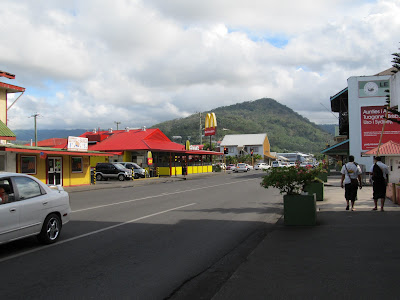
A typical street scene in Apia

Culturally, Samoa seems to be more similar to conservative Christian Tonga than to more liberal Fiji. There were churches every half mile or so on the way from the airport, some with very bright coloring, and the entire town basically shuts down on Sundays. Apparently the early missionaries had a much easier time reaching the Samoans because they already believed in the "invisible creator in the sky". The missionaries main cultural effects were getting rid of cannibalism and convincing the Samoans to stop killing each other. They are a warrior culture, the more battles that a family won the more power and respect they got. Family is an essential part of the culture, each family owns land and the extended families all live near each other in their own villages. Each nuclear family has their own house and the extended family meets and shares meals in a fale (fah-lay), basically a large room with no walls. Each family has a high chief and one or more talking chiefs, which can be men or women, and are voted into "office" by the family, based on how well they have served the family. The talking chiefs are very involved in the discussions amongst the family, while the high chief is mostly a listener, but the high chief has the final word on any decisions or disagreements.
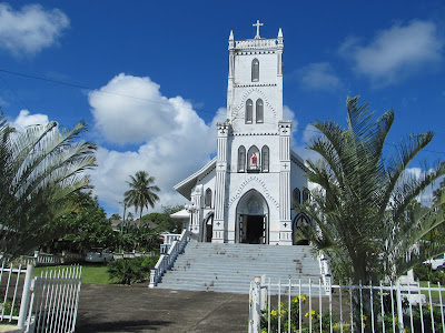
The Catholic church in which we were allowed to observe the service

One fascinating part of the culture is the tattoos. Apparently the missionaries tried to stop that too, but there was no way the Samoans would give it up. Our tour guide around the island (I'll elaborate on the tour later) told the story of getting his "full body" tattoo, which means from the knees up to the obliques, not actually the entire body. It is basically a male right of passage but not all men do it because it pretty much sounds like one of the worst experiences I could imagine. So, before they get the tattoos, the artist has to make sure the person is mentally and physically ready, most that think they are, are not. The artist basically tries to convince you not to do it by describing all of the consequences in great detail, so you are fully responsible for what you're about to do. The artist also must have gone through this themselves. If you die in the process, there is no suing or prosecuting the artist, it's your fault. I know you may be thinking, "it's just a tattoo, yeah they hurt, but it couldn't be that bad," and you would be wrong. First, if you start the process and don't finish, your entire family is permanently shamed, some that don't finish even commit suicide to avoid the shame. The process takes 12 grueling 5-6 hr sessions usually spread out over a few weeks. The tools are basically sharpened bone chisels attached to wooden rods, and sound far worse than needles or bamboo. When the process starts, they strip you down and hold you down with your stomach on a tree stump and don't let you get up until the session is over. The bleeding is pretty horrendous and some even die from blood loss. Not only is the chiseling extremely painful, but your muscles and ribs ache like crazy from being held down on the stump for hours. The guide said it felt like someone had ripped his skin off. After the session, the artist's sons take you in the ocean and force you to submerge the wounds, and of course the salt feels lovely too. To keep the wounds clean and prevent them from scabbing too much, you have to get in the ocean every few hours for the entire process. While in the ocean, kids from the village surround you to beat the water with sticks so you don't get attacked by the fish that are swarming to the blood in the water. They give you a thin mat to sleep on, which of course sticks to your bloody wounds, and no mosquito net, so your wounds get covered in flies too. The sessions are 2-3 times a week to give you a little recovery time in between. You are essentially tortured for 6 weeks, and the guide said he began to hate the artist and everyone involved because of it and he seriously contemplated suicide after the first session. If you manage to make it through this without killing yourself, bleeding out, or dying of infection, you gain respect from everyone. But more importantly, you gain more appreciation for life, knowing that you could have died in the process, and from then on, nothing is difficult anymore. There is literally nothing that can faze you after this experience, no matter what you do it will be easier than what you went through. As you can tell from the amount of detail I just gave, it was an amazing and captivating story, I can only begin to imagine what it's like to go through something like this.

Alright, on to lighter subject matter, the food in Samoa. The second day here (sat 11/5), we got some food at a cafe in town, where I had pretty much the worst "burger" I've ever had. The "beef" patty looked like it was breaded and while it didn't taste horrible, it did not taste like beef. The only toppings were coleslaw, something similar to mustard and something that resembled thousand island, and it didn't even come with fries. The food here in general is pretty bland, no spices and the sauces don't have much flavor. There are cows on island, but the "steak" I had earlier tonight at the hotel restaurant, was pretty low quality and looked like it had been flattened with a tenderizer. However, I did have a large and quite fantastic ahi steak at a restaurant last night, so there is some good food available. You can't drink the tap water, similar to Fiji and Tonga, but there is a pretty decent local beer called vailima that is about $2-2.50, or you can pay over twice as much for corona, heineken, stella, or good ol' coors light. Alright, enough about food for now, it's clearly not a reason to come to Samoa.

On to the island itself... On Sat after lunch, we walked to a marine reserve that was a 10 min walk away, and stopped to watch an outrigger canoe paddling race along the way. We rented snorkel gear at the reserve and swam out a few hundred yards to palolo deep, which apparently gets up to 80 ft deep and is a scuba diving spot as well. The main difference from Hawaii was a lot more quantity and variety of coral, and much more of it was living. The most common kind was branchy and tan with bright blue polyps sticking out of the ends of the branches, but there were many other varieties as well. There was a good variety of fish, and one huge school of 500-1000 small bright green-blue fish. Otherwise no particularly exotic creatures, but it was pretty good snorkeling overall. On Sunday, we took a tour of the eastern half of the island, with the aforementioned tattooed tour guide, who was pretty awesome in general. There were ~15 aussie and kiwi tourists with us, including one samoan aussie who I chatted with for a while when we made a lunch stop at a beach. Turns out he is a pro rugby player and a pretty nice dude; he told me he was going to propose to his aussie girlfriend on the trip. Anyway, Apia is on the north coast and we first headed east along the coast. We passed by lots of small villages and many more churches, we even were allowed to stand in the back of a catholic church and watch part of the service, which was a little more lively than most services, but not that much different. One thing that struck me is that there were very few sandy beaches, they were mostly rocky. Considering that this island hasn't had an eruption in a long time, this was surprising. Could be due to subsidence causing the beaches to be drowned, the lack of parrotfish to eat and poop out coral bits, or maybe due to relatively steep cliffs along most of the coast that could be burying the sand with larger rocks and debris. Another thing that struck me was how green and lush the entire island is, very different than the wet east sides vs dry west sides in Hawaii. The entire island was as lush as the greenest parts of the Hawaiian islands. This is primarily because they don't have tradewinds consistently blowing in one direction, but this fact also makes the humidity much harder to deal with. We saw a couple waterfalls which were pretty but not amazingly impressive. We did stop at one beautiful sandy beach for lunch, that had these little beach huts that you could rent, which were basically a straw roof over a slightly raised wooden platform. I guess they give you a mattress, pillows, sheets, and a mosquito net, and they serve food in a little building across the street. After the beach stop, we cut in through the center of the island, our tour bus definitely had some trouble getting up the hills, which wasn't helped by the fact that it had a manual transmission. We saw a pretty waterfall called Papapapaitai near the middle of the island, which was maybe 200 ft tall. The last stop was at a Baha'i temple, which had a very unique shape and some beautifully maintained grounds around it. Apparently, it is #4 out of 14 of these temples in the world. We were allowed to walk inside and check it out. We ended up back in Apia after a ~6 hour tour, definitely worth the time and money. So, I think that is all I have on Samoa at the moment, I'll add more if I think of anything worthwhile, and I'll add some pics once I get them off my camera. Feel free to post comments or questions, I'll answer what I can...
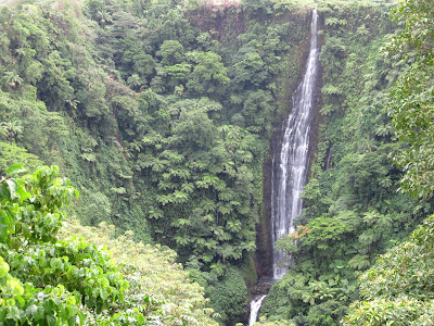
Papapapaitai Falls, ~200 ft tall, the ferns make it appear smaller, but they're just really big ferns

Faofao beach, our lunch stop on the island tour

A beautiful and extremely secluded little resort on the SE side of the island.