1) My opinion of the food has improved a bit since the beginning, although overall it is still not quite as good as the KM. The quality of meals is generally more variable, but we have had some pretty delicious stuff and there is a little more variety in the types of food than the KM. We had rack of lamb last night along with a pretty good chicken curry, we had a nice turkey/stuffing/mashed potatoes/gravy type meal for Christmas, and supposedly we are having a bbq for New Year's day tonight. We've had chow mein and fried rice, various types of soups, fried chicken, sandwiches, short ribs, burgers, hot dogs, and more. There is a somewhat disappointing variety of veggies in the salad bar though, the KM salad bar definitely was better. The KM had some good snacks, but it was the same stuff for the entire cruise, whereas they keep pulling out new snacks every few days on this boat. They have chocolate, candy, multiple kinds of chips, beef jerky, fruit snacks were just brought out yesterday, and I'm sure we'll see some more snack variety before the cruise is over. Probably the only advantage in terms of food that the Langseth (my first ship) had over the KM and the Thompson is the ice cream, they had six huge tubs of it that were constantly available. One of them was rainbow sherbert, which was pretty much all the dessert I needed on the first cruise. Others with more normal tastes in desserts would probably appreciate the fresh made cakes, pies, cookies, and pastries more than I, but I rarely eat any of those. They do have egg nog on this boat though, that is my typical dinner time dessert (although as with all store brand egg nog, it pales in comparison to Berkeley Farms egg nog. If you live in the Bay Area, you probably know what I'm talking about).
2) The crew on this boat seem to be the least friendly of the three overall, although on every cruise there seems to be at least a few crew members that for some reason don't like the scientists (specifically the male scientists). They always seem to be friendly to the female scientists though, which I guess is not surprising since the ratio of men to women is usually around 10:1. The crew has sort of made the library their "territory" and the one time I went in there a few nights ago I felt like I was interrupting a private party and got some dirty looks from a few people in there. With that said, there are plenty of nice people in the crew that I've chatted with a bit, and the marine techs (the people who work directly with the scientists) are nice, as they usually are. I don't want to make it seem like the crew is mean or anything, I just feel like there are a few of them that are resentful of us for some reason and just aren't very friendly (Sam (another UH grad student) has noticed the same thing, so it's not just me). We'll see if my opinion changes as the cruise goes on, it could just take them a little while to warm up to us.
3) We have had issues with just about every piece of scientific equipment so far; nothing that is preventing us from getting the data we want, but everything has not gone smoothly. The deep-towed sonar has been having problems, mostly on the starboard side, since the beginning. The sidescan returns were very weak for the first survey and the bathymetry data pretty much looked like crap, maybe a third of the starboard swath was actually usable data. After the first survey area, they found a short in the starboard electronics and fixed it, so it has improved for the beginning of the second survey area, but apparently it is still not quite as good as it should be. One of the MAPR's, which is an instrument that we attach to the sonar tow cable to detect the signature of a hydrothermal plume in the water column, crapped out on us as well, but there are extras so it wasn't a big deal. The dredging also has not gone as well as hoped. They have had a few good dredge hauls with a fair number of rocks, but some of the dredges have come up empty and many have been very small. They were actually picking little tiny bits of rock off of the deck with tweezers on a few dredges because they needed to get every last bit of rock that they could. On the last cruise, we would have just swept that stuff overboard, we always got at least a full 5 gallon bucket worth of rocks, and sometimes as much as 8 full buckets. The variety of the rocks in the first survey area was also not very exciting. All of the samples were pretty much the same stuff: all basalt (the typical lava composition erupted at most spreading centers), with no visible crystals, not much variation in texture, and very few vesicles (gas bubbles). It definitely makes me appreciate both the quantity and variety of rocks that we got on the last cruise. However, we are now mapping the forearc rifts and will be dredging these after the mapping is done, so we will almost certainly see a greater variety of rocks along these structures than the first survey area which was along the backarc spreading center.
4) Two nights ago was the best stargazing I've seen on any of the cruises so far. There were a ton of stars and I could actually see the Milky Way, which I have not seen on either of the other boats. I spent almost an hour laying out on the hammock, listening to some tunes, and looking at the stars, it was really nice. It helps that the fore deck of this ship is darker than the other two so there is less light to interfere, plus there was no moon. However, I still don't feel like it was better than the stars I've seen camping out in the Sierras or Northern California, you just can't get complete darkness because they always have to have at least some lights on on the ship.
5) We did have a mini New Year's Eve celebration last night in the main lab. The scientists from U. Rhode Island and UT Dallas bought a blue godzilla pinata in Guam and we had some fun taking turns hitting it, so it was nice to do something a little festive. Otherwise, New Year's pretty much has felt like any other day on the cruise. In case I hadn't mentioned this already, alcohol is no longer allowed on American research vessels, so there was no champagne to start the new year.
Saturday, December 31, 2011
Sunday, December 25, 2011
The Instruments
As I mentioned in the last post, there are three legs to our survey: two along the forearc rifts and one along the spreading center north of them. The primary mapping instrument we are using is deep-towed sonar. There are two instruments: the IMI-30 and the IMI-120. They are both sonar systems that are towed on a cable relatively close to the seafloor. The IMI-30 is slightly lower resolution (~5 m) and towed ~500 m above the seafloor, but gives you slightly wider swaths of data. The IMI-120 is towed ~100 m above the seafloor, gives you narrower swaths, but higher resolution (~1-2 m). For comparison, ship-mounted systems have resolutions of 30-100 m, depending on water depth and the frequency of the instrument. As I explained in a previous post ("Sonar Mapping" in the "The Mission and Instruments" section of the blog on the previous cruise, 11/12/11), sonar systems emit sound waves that bounce off the seafloor and return to detectors on the instrument. There are two types of measurements: bathymetry and sidescan (aka backscatter). For bathymetry, the instrument measures the travel time of the sound beams and converts it to a distance to give a map of the topography of the seafloor. Sidescan (backscatter) is a measure of the intensity of the reflection, which is affected by both the type of material and the orientation of the seafloor relative to the instrument. Harder surfaces (such as fresh lava flows, or rock that is exposed along a fault scarp) give a stronger reflection while softer surfaces (such as sediment) give a weaker reflection. With an instrument mounted on a ship that is a few 1000 m above the seafloor, the type of material is the primary thing that is picked up in sidescan imagery, the orientation of the seafloor does not have much of an effect because it is so far away. You essentially end up with a black and white image of the seafloor that shows you where highly reflective recent volcanism and faults are, and less reflective sediments are. However, with a deep-towed instrument, since it is much closer to the seafloor, the topography of the seafloor becomes a much bigger factor. Imagine if the instrument was flying through a valley that is 200 m deep but it is only 100 m off the bottom. It will not be able to "see" over the edges of the valley and thus you will get no reflection from outside of the valley. Also, if the instrument is flying along a steep slope, it will get a very good return from the upslope side but will get very little reflection from the downslope portion. If there is a volcano on one side of the instrument, the side of the volcano facing the instrument will give a strong reflection, but there will be a "shadow" on the opposite side because the sound waves are not hitting that side. Deep-towed data also tends to degrade toward the edges of the swath and is usually not very good directly below the instrument because the beams are oriented toward each side not vertically (hence the "sidescan" name). However, you can see MUCH more detail than you can with instruments that are mounted on the ship, allowing you to identify individual small faults and lava flows and even see the texture of the surface of a lava flow so you can tell what kind of flow it is. In an image from a ship-mounted system, you would just see dark and light patches, and only large faults will show up. We are primarily using the IMI-30 because it allows us to cover a wider area while still giving great resolution and has less distortion than the IMI-120. We will use the IMI-120 if we want to examine a particular area in greater detail or if the IMI-30 craps out on us. We will be towing these instruments along the length of the rifts and the spreading center, providing much more detailed maps of the volcanic and tectonic structures than we currently have. It will eventually be my job to interpret these detailed maps and try to figure out what is going on in this region (I honestly don't know exactly what I'll be saying in the papers I'll be writing because I haven't seen any of the data yet). We are basically driving the ship in straight lines along the features, collecting 2 or 3 parallel overlapping swaths of data for each of the features.
 A small (I couldn't get a larger version without signing in) schematic image showing the deep-towed sidescan sonar setup. You can see how the beams are oriented, the blank spot directly below the instrument, and the strong reflections/shadows on either side of the volcanoes. I'll post an actual image of what the data looks like later.
My job on this cruise is to do some of the initial processing (called "bottom detect editing") of this data as it is collected. I work a 9 hour shift from 6 pm-3 am. Fernando's (my advisor) other student, Regan, is doing another 9 hour shift from 3 am to noon, and one of the employees of the group that owns and operates the instrument (Hawaii Mapping and Research Group (HMRG)) is covering the noon to 6 pm shift. It is somewhat difficult to explain what exactly I'll be doing and I'm not fully comfortable with all of the technical details of how these instruments work, but basically I'm making sure that the instrument knows where the real bottom is. Because we're dealing with sound waves and they aren't as precise as something like a laser, there are a lot of echoes and reflections that confuse the instrument. The instrument has an array of transducers (the things that emit and detect the sound waves) on either side, roughly oriented 45 degrees from vertical. Sometimes the sound reflects off something in the water column that is not actually the seafloor, and sometimes the sound waves from one side of the instrument are picked up on the other side of the instrument. This can make the instrument confused as to where the real bottom is on a particular side. So I look at the raw data right after it's collected and try to find the reflection that represents the "true" bottom. However, because we don't actually know definitively where the bottom is, it can be very ambiguous sometimes, especially when the topography is complex and/or different on either side of the instrument. The guy who is in charge of HMRG calls it a "dark art" rather than a science, and this is an apt description. The basic idea is not to be 100% precise on getting the actual bottom, because you can't, but rather to make the image more believable and easier to interpret and to eliminate the obvious errors. Sometimes it is very clear where the true bottom is, sometimes it is not clear at all. So far, it has been going pretty well, there have definitely been some ambiguous swaths, but I'm getting more and more comfortable and efficient with the process. Unfortunately, the first survey area is along the spreading center, which is the simplest of the three survey areas, so it will likely be more difficult for the other two areas.
The other major part of the mission is sampling the volcanic features that we see in the sonar data. I will not be involved in this part of the operation, beyond checking out some of the rocks for fun. There is another group of grad students from University of Rhode Island and University of Texas Dallas who are covering this part of the mission. There are two main sampling methods: wax coring and dredging. I have described dredging in detail (see "The Mission and Instruments" post from the last cruise, 11/12/11) previously, so I won't talk much about that. Wax coring seems to be kind of a lame sampling method and doesn't really produce great samples, I think dredging will end up being the primary method. No dredging has occurred yet, we are waiting until we map the first area to identify good sites to dredge, but we did do a few wax cores when we had to pull up the deep-towed sonar for repairs two days ago. It's basically a cluster of small metal cylinders filled with wax that have a heavy metal weight on top and are attached to a wire extending from the ship. It's a pretty simple process, they basically just drop the thing overboard and let gravity slam it into the seafloor. Ideally little bits of rock will get stuck in the wax, which can then be removed and analyzed. To any non-geochemist, the samples are not impressive at all, they are literally tiny mm-sized bits of rock (or sediment if you're unlucky) that aren't much to look at unless you have a powerful microscope. They still can do chemical analyses of the tiny samples, so it is useful, but definitely not the best sampling method. Dredging may be imprecise, but at least you get lots of rock to look at. I'll post some pics once we actually get some dredged rocks. I think that covers the gist of what we are doing.
Science Background
So as far as scientific research cruises go, this one is a little more traditional than the previous one. Instead of being funded by a seafloor mining company, this cruise is funded by the National Science Foundation (NSF). My advisor, who is the chief scientist for this cruise as well, applied for grant funding for this project, which is paying for the ship time as well as my meager salary. The cost of a ship per day is on the order of $25,000-$30,000 (up to $50,000 for certain ships), so research cruises are definitely not cheap. The area that we are working in is the southern Mariana Trough, which is ~100 miles southwest of Guam. This is another backarc basin environment, similar to the Lau basin (for a description of what a backarc basin is, see my previous post, "Science Background" on 11/11/11, or a really old post from the first cruise, "The Science of it all," although I misspoke in that post saying that the subducting plate melts to create the arc volcanoes. This is not true. Water released from the subducting slab causes the mantle above to melt, the slab appears to not melt much at all and can still be seen in mantle imagery (tomography) sometimes as deep as the core-mantle boundary.)
The Mariana Trough is the southern portion of the Izu-Bonin-Mariana Arc system, which is a subduction zone that stretches all the way up to Japan, and is the geologic feature along which the recent devastating earthquake/tsunami in northern Japan occurred. I don't know quite as much about the complex history of this area, but the basic situation is that the Pacific plate is subducting under the Phillipine Sea plate (a small plate sandwiched between the Pacific and Eurasian plates) in a roughly W-NW direction, creating a chain of arc volcanoes and a well developed backarc basin seafloor spreading system. For a more detailed but not-too-technical description of this area, check out the wikipedia page: http://en.wikipedia.org/wiki/Izu-Bonin-Mariana_Arc. This area has been active for much longer than the Lau basin (~50 My instead of only 5-6 My for the Lau basin), and so has a longer and more complex history. One interesting thing here is that there has been two episodes of arc rifting, creating two backarc basins. The first episode separated the Palau-Kyushu Ridge on the west side of the system from the Izu-Bonin-Mariana arc, leaving behind the extinct Parece-Vela and Shikoku basins (see the map below). Then in the southern portion of the system, a more recent episode of arc rifting has formed the much smaller and still active Mariana Trough, which is the region that we are focused on. At the southern end of this trough, along the trench where the two plates converge, is the famous "Challenger Deep," the deepest part of the ocean in the world at almost 11,000 meters, although it is still possible that a slightly deeper trench may yet be found.

Map of the entire Izu-Bonin-Mariana (IBM) Arc system. We're looking at the southern Mariana Trough west of Guam and the region between Guam and the trench.
As you can see from the maps, the trench runs roughly N-S for most of its length, but along the southernmost portion of the system it makes a sharp bend and becomes almost E-W. The geometry of the subducting slab here is very complex and not entirely known. There appears to be a tear in the slab near the SW corner and while for the N-S portion of the system the slab is subducting in a W-NW direction under the basin, in the southernmost E-W portion, a small chunk of slab appears to be subducting in a more northerly direction. This piece of slab is plunging almost vertically down into the mantle, which is part of the explanation for why the Challenger Deep is so deep here. But, to make it more complex, while this chunk of slab is subducting toward the north, because it is still attached to the Pacific plate, it is also moving W-NW. This creates strike-slip motion along this E-W trending part of the trench, the Pacific plate is moving toward the W, and the Mariana Arc is moving toward the E as seafloor spreading continues in the Mariana Trough. There is another short wikipedia article on the Mariana Trough for those who want a little more info: http://en.wikipedia.org/wiki/Mariana_Trough. Friction along this boundary causes the overlying plate to rift apart, creating widening cracks that stretch from the trench to the backarc spreading center.

Bathymetry map of the Mariana Trough. We are mapping the area W and SW of Guam. Unfortunately the spreading center is not marked here, but it is ~1/2 way between the ridge that Guam and Saipan are on and the West Mariana Ridge. You can see in the north that the ridges have not yet split apart and are still a continuous volcanic arc. The dark blue crescent-shaped feature is the trench itself, you can see how it changes from ~N-S to ~E-W.
These rifts are the primary focus of our mapping and sampling, and have never been examined in much detail before. They also will be a major focus of my PhD work, the data we are collecting during this cruise will be the primary data set for most of my PhD. These rifts are called the Southeast Mariana Forearc Rifts (SEMFR), and there are two primary ones that we will look at. Unfortunately they are too small to be seen on the maps I've posted here, I'll try to get some more zoomed in maps later. Our survey will be divided into three legs, two of them along the two rifts, and a third along the spreading center N of these rifts. Less detailed mapping of this region has shown that there is active volcanism along parts of these rifts. As the crust is stretched and pulled apart, the mantle rises to fill the space and melts because of the reduced pressure, creating volcanic eruptions along these rifts, which is roughly similar to what happens along spreading centers. These rifts are unique because the slab is much shallower underneath them, starting at a few km depth near the trench and increasing to a few 100 km by the time you reach the spreading center. Normally, the first volcanism that occurs is along the volcanic arc (the row of circular red/yellow features that run along the west side of Guam and Saipan on the map above), where the slab is ~100+ km deep in the mantle. Between the arc and the trench (the forearc), the mantle typically does not melt, and even if it does, the crust is too thick for the melt to penetrate. But because of these rifts opening up in this region, the water-rich melt rising in the mantle has a window to get out onto the seafloor. Also, because the slab is so shallow and there is so much water being released from it, the mantle is relatively cool, so you don't get "normal" types of lavas that you would see along a spreading center or one of the arc volcanoes. I'll give some more details on this once we actually get some samples of this stuff, but one of the things I expect to see is serpentinite. Serpentinite is what is formed when the mantle (which is largely a rock called peridotite) reacts with water and incorporates it into the crystal structure (it is ~40% water by volume), and this can actually erupt onto the seafloor as serpentinite "mud". This requires relatively cool temperatures and lots of water, which is what you find in the shallow part of a subduction zone. Serpentinite is the state rock of California, and is normally found within the oceanic crust where water has reacted with the mantle. In California, it was scraped off onto the continent from the top of the subducting Farallon plate, it was not actually erupted onto the seafloor. It is very rare for it to be erupted onto the seafloor, so I am excited to see some samples of that. I think that covers the basic scientific background, I'll get into what we're doing and the instruments we're using in the next post. I tried to make this explanation accessible to non-geologists, but it is rather difficult, so if anything is confusing, let me know in a comment.
Saturday, December 24, 2011
Onboard R/V Thomas G. Thompson
Well, the two week break between cruises went pretty quickly, as expected I guess, and now I am on the Thompson for the next cruise. I arrived in Guam on 12/20 (I left HI on 12/19 but we are 20 hours ahead here). This time I really didn't get any time to explore the island since we boarded the ship the day after I arrived. From what I saw and what I've heard Guam isn't the most exciting island to visit anyway. It sounds like the primary reason to come here is for scuba diving, which I have heard is very good. Unfortunately I won't get a chance to do any diving since I don't really have the money and I didn't want to stay very long after the cruise since I've been away from home so much. All that I saw of the island was on the drive from the airport to the hotel and from the hotel to the harbor (which is inside of a Navy base), as well as a quick stroll along the beach by the hotel. It has a very strong American influence since there are some massive military bases on the island and it is an American territory. Most of the typical fast food restaurants and stores that you would see in just about any American city are there and everyone speaks English. It basically looks like an average American city for the most part, although there are some pretty decent tropical beaches. Apparently, it is a big place for Japanese tourists, it was described to me as the Japanese Waikiki, it's where they go to get a taste of some tropical beaches. It's about the same distance from the equator as Samoa (~13 N), so it is a little hotter and more humid than Hawaii, but since it is winter in the northern hemisphere, the weather is generally more pleasant than Samoa. It sounds like there is a possibility of typhoons coming through, but so far the weather and the seas have cooperated, I'm already used to the motion of the boat and off the dramamine after 3 days.
The boat itself is significantly larger than the Kilo Moana, meaning that there is a lot more lab space, more deck space, and the rooms are larger. All of the science people have their own rooms, which is really nice. However, despite the fact that the room is almost three times the size of the Kilo Moana rooms, the beds are still the same tiny size. They could have easily added a foot or two of width to the beds and still had plenty of floor space, I'm not sure what they were thinking on that one. Beyond the larger size of the Thompson, the Kilo Moana is pretty much a nicer boat in every way. It is newer and cleaner, and the food was significantly better (although it's pretty hard to beat the food on the Kilo Moana, so that is not unexpected). We did have some surf and turf last night (steak/lobster), so there is good food onboard, but just not as consistently good so far, and generally lower quality. There are more public computers available and slightly faster internet, so that is a plus. There is a pretty decent lounge with a nice big TV and a bunch of movies, but the 70's fake leather seats and couches are not nearly as comfy as the huge soft black leather couches on the KM. The gym is also not quite as nice as the KM, they have a bench with some dumbbells, a decent non-electronic exercise bike, and a broken treadmill. I'm not sure why they thought free weights on a moving ship was a good idea, the KM had a pretty nice weight machine that seemed a lot more appropriate for a boat. But it's better than nothing, I've already used the gym twice. I think that covers the basics of the boat, let me know if you have any questions. I'll get into the scientific aspects of the cruise and my job on the next post...
The boat itself is significantly larger than the Kilo Moana, meaning that there is a lot more lab space, more deck space, and the rooms are larger. All of the science people have their own rooms, which is really nice. However, despite the fact that the room is almost three times the size of the Kilo Moana rooms, the beds are still the same tiny size. They could have easily added a foot or two of width to the beds and still had plenty of floor space, I'm not sure what they were thinking on that one. Beyond the larger size of the Thompson, the Kilo Moana is pretty much a nicer boat in every way. It is newer and cleaner, and the food was significantly better (although it's pretty hard to beat the food on the Kilo Moana, so that is not unexpected). We did have some surf and turf last night (steak/lobster), so there is good food onboard, but just not as consistently good so far, and generally lower quality. There are more public computers available and slightly faster internet, so that is a plus. There is a pretty decent lounge with a nice big TV and a bunch of movies, but the 70's fake leather seats and couches are not nearly as comfy as the huge soft black leather couches on the KM. The gym is also not quite as nice as the KM, they have a bench with some dumbbells, a decent non-electronic exercise bike, and a broken treadmill. I'm not sure why they thought free weights on a moving ship was a good idea, the KM had a pretty nice weight machine that seemed a lot more appropriate for a boat. But it's better than nothing, I've already used the gym twice. I think that covers the basics of the boat, let me know if you have any questions. I'll get into the scientific aspects of the cruise and my job on the next post...
Friday, December 2, 2011
The Final Post (until the next cruise...)
Well, we are officially nearing the end of the cruise, less than 3 days left until we’re back in Apia. I have had some interesting experiences, seen some cool rocks, and eaten some delicious food, but it is safe to say I’m ready to be back home, especially with the prospect of another month-long cruise looming in less than 3 weeks. We have completed 25 dredges, with two (or maybe 3) more planned for tomorrow (Saturday). Then we will start transiting back to Apia around 2-3 am Sun morning, hopefully arriving in port on Sun afternoon and getting off the ship by 8 or 9 pm Sun night. Then, a 2 am ~4 hr flight to Auckland, NZ, a ~6 hr layover there, and another ~9 hr flight back to Honolulu. Needless to say I’m not looking forward to that. We’ve still only had one dredge with a significant amount of sulfides in it, unless we get really lucky tomorrow. The AUV is still having issues, the last few times it has only come back with at most a third of the data it should have collected. Apparently, the data-related problems are nearly all due to the multibeam sonar unit made by a company called Reson (not the German company Geomar that owns the AUV itself). It’s possible Reson may get sued for lost ship time (which is in the range of $30,000+ a day) but I’m not entirely sure. One side benefit for me (and my advisor) to all of the AUV problems is that we have gotten to do a lot more mapping with the ship's multibeam sonar system than we initially expected to do. We have filled in a number of gaps and extended the width of some of the previously mapped areas, which will be quite useful when I start looking at this area for my first PhD paper. Overall, this cruise experience has been significantly better than my first cruise on the Langseth, although 30 days is still a long time to be on a boat. The ship is nicer, food is MUCH better, the shorter duration of the cruise helped, having the previous experience under my belt also helped, and in general I had a better attitude about this cruise from the beginning. On the last one, I focused too much on how long I was going to be stuck on the boat and was just too negative in general, whereas I had a much more accepting, go-with-the-flow attitude this time. Attitude certainly makes a difference. Well, I think that’s all I’ve got for now, I’ll probably start the next episode by 12/22-12/23 when I am onboard the R/V Thomas G. Thompson south of Guam.
 A photo from one of the nicer sunsets, thought it was appropriate for the final post.
p.s. I'm still going to attempt to upload more photos to previous posts, although probably not as many as I would like given the painfully slow internet connection. Update: Done!! Check the older posts for new photos.
Friday, November 25, 2011
Update Time!!
So it is the day after Thanksgiving, a little over a week left in the expedition. The Thanksgiving feast definitely lived up to expectations, the food on this boat has probably been the highlight of the trip so far. I would put the quality of this food up against just about any restaurant I’ve ever been to, I’m truly impressed with what the cooks can do on a ship. We have done 18 dredges now and still no metal sulfides (except for the tiny piece with pyrite on it) to make the Nautilus folks happy. The lavas have ranged from rhyolite pumice, which we haven’t seen much of since the first few dredges that were very close to the arc volcanic front, to the boninites that we saw early on, and more recently we have seen dacite, some of it very fresh, possibly erupted within the last few years, and even some basaltic andesite. The continuum of lava compositions based on silica composition is basalt (at the low end), andesite (intermediate), and rhyolite (high silica). It is MUCH more complicated than that, but those are the big three that you would learn in a basic geology class. Dacite falls between andesite and rhyolite, so it is a relatively high silica lava, and the stuff that we found was very glassy (cooled quickly) for the most part, almost like obsidian. We may have found some basaltic andesite in the last dredge since we are now dredging the Fonualei spreading center, significantly further from the arc and the influence of water in the mantle, which tends to create higher silica lavas. The only truly unique material was the previously mentioned sulfur.
 A cool texture from the underside of a basalt sample. This texture forms on the underside of the roof of the lava flow from the lava dripping when the molten material drains out quickly.

Supposedly in the latest AUV survey, they were able to identify some hydrothermal chimneys, so the next dredge in a few hours may actually find some sulfides or at least some hydrothermally-altered rocks, and perhaps some more deep sea critters. However, as I’ve mentioned it’s very difficult to target a small patch of seafloor with a dredge, so we may yet strike out on sulfides. I’m sure the critters will appreciate it if we miss the hydrothermal vent with the dredge. Apparently an ROV is a much better tool to sample hydrothermal vents, since it can be remotely controlled by someone from the ship and has video capability so they can see exactly what they are sampling. The AUV is really just a small-scale mapping tool that may tell them where the vents are located, but it sounds like it would be ideal to have both and AUV and ROV to really locate and sample the hydrothermal materials. Since Ken is not particularly interested in sulfides, he’s been pretty happy with all of the lavas that we’ve found, and hopefully once he analyzes the lavas back at UH, I will ultimately be able to correlate some of his findings with my own observations on the morphology and structure of the spreading centers. Fernando has also gotten them to sneak in a little mapping here and there on transits to various AUV sites to fill in some of the gaps in the bathymetry maps of the area, so that data will be directly useful for my PhD work. We still have some delays with the AUV, although it seems that most of the instrument/software problems are pretty much resolved by now. The problem is that these types of issues should have been resolved before the AUV was ever taken out to sea. We have lost a few days of valuable ship time with all of the AUV issues, something that no one is happy about. Apparently this particular AUV has not been used on a full science mission before and it seems that the crew in charge of it is not particularly experienced or competent, which has exacerbated the problems. They also refuse to deploy the AUV in even slightly rough seas and they won’t deploy at night, so it forces everyone to work around their schedule. I think it’s safe to say that Nautilus will not be using a Geomar AUV in the future. Nautilus is also the first company to use these methods for hydrothermal exploration, so we are essentially testing a whole new methodology for this type of work, which is also the cause of many of the delays and scheduling issues. The TowCam has had a few issues as well, but the dredging has had no problems at all. I guess it’s not surprising that the most low-tech instrument has the least number of problems. The TowCam has come up with some pretty cool photos though, including hydrothermal cracks and mounds on the seafloor, interesting pillow lava structures, huge beds of mussels surrounding hydrothermal vents, shrimp, crabs, fish, branchy and whip corals, crinoids (animals that look like flowers attached to the seafloor), and even an eel that was hiding from the cam under a rock. I’ll try to post a few of these, but with this brutally slow internet connection it’s going to be very difficult. I still want to post a few pics of Samoa too, but it literally takes 10-20+ minutes to upload one photo and sometimes it has an error during the upload and just doesn’t work. The internet connection has been a constant source of frustration.
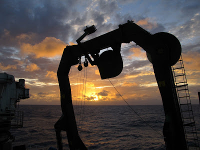
A beautiful sunset through the A-frame on the aft (rear) deck of the ship. This is the structure that the winch controlling the dredge is routed through.
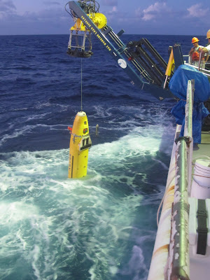 AUV deployment in action!
Last night, I spent some time out on the upper deck by the bridge listening to some Bonobo (perfect star-watching music) and enjoying some fresh air. There was a beautiful view of the stars and it was refreshing to feel the wind whipping against me, I think I’m going to do that just about every night for the rest of the cruise. I saw a couple shooting stars and even a few flashes of lightning way off in the distance. But, as with my experience on the Langseth previously, the star-viewing is still not as good as I’ve seen out in the mountains of California. Even though there are only a few lights on the ship, it is enough to spoil what should be a perfect view of the night sky. I’ll try to get in at least one more update before the end of the cruise, but that’s all for now…
 A cool texture from the underside of a basalt sample. This texture forms on the underside of the roof of the lava flow from the lava dripping when the molten material drains out quickly.
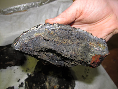
A really cool example of basalt. The right side (black layer) is the glassy top of the lava flow, getting deeper toward the left, where a huge number of green olivine and clinpyroxene crystals have accumulated by settling toward the base of the lava flow.
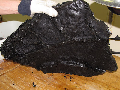
 I know I had said in this post that we hadn't found sulfides, but we finally did find some in a later dredge. They're hard to see in this pic but the darker gray stuff toward the interior is Galena (lead sulfide), and there is a tiny amount of copper and zinc sulfide in some of the samples. It actually looks cooler with a hand lens when you can see all of the individual crystals.
 I know I had said in this post that we hadn't found sulfides, but we finally did find some in a later dredge. They're hard to see in this pic but the darker gray stuff toward the interior is Galena (lead sulfide), and there is a tiny amount of copper and zinc sulfide in some of the samples. It actually looks cooler with a hand lens when you can see all of the individual crystals.
A beautiful sunset through the A-frame on the aft (rear) deck of the ship. This is the structure that the winch controlling the dredge is routed through.
 AUV deployment in action!
Thursday, November 17, 2011
Update after a week
It is now Thursday 11/17, and we have completed 10 dredges. At this point I think I can safely safe that I’ve had my fill of dredging, for life. We’ve seen some interesting rocks, but you can only get excited about black lava rocks with varying amount of crystal and bubble content for so long. The most unique rocks that we recovered were almost pure sulfur. We actually dredged over a molten sulfur pond, which we could see stuck to the outside of the dredge bag. We also saw samples that appeared to be from the surface of the sulfur pond which had frozen “ripples.” There were also some really cool sulfur crystals, which I grabbed some take home samples of, as well as some sulfur spherules (basically small round globs of sulfur). Beyond that, most of the dredges after the first three, which were largely pumice, have been boninite lavas. To the non-geologist, they basically look like dark gray to black lava rock, and you really have to be a geochemist or petrologist to get excited about the variety within those. The most interesting examples of those rocks were some with very large crystals of olivine and pyroxenes, which I also grabbed some personal samples of. The only metal sulfides we have found, which is what Nautilus is interested in, were a couple tiny pieces with even tinier crystals of pyrite (fool’s gold), which is iron sulfide. Even though they have been trying to target the hydrothermal sites where the metal sulfides should be found, it is very difficult to target a specific area of seafloor with the dredge. We also dredged up a few deep sea creatures, including fragments of mussels, shrimp, coral, a crab, and even an eel-like fish. Thankfully we didn’t massacre too much life (only 7 or 8 creatures total), it is definitely an ethical issue that the non-Nautilus scientists are concerned about. We are freezing all of the life we find to give to a biologist for analysis. The process of deploying and retrieving the dredge, getting the samples out of the bag and organizing them in the lab has definitely lost its luster at this point. I end up absolutely drenched with sweat after every dredge, especially during the day, so I’ve had to get used to feeling disgusting most of the time. My personal favorite part, which the crew and other scientists gladly let me take care of, is beating the crap out of the dredge bag with a sledge hammer to knock all of the samples loose. It’s a nice aggression release and a pretty good workout too. It’s also fun working with Ken, who has a never-ending supply of stories about past cruise experiences and people that he has worked with, as well as gossip on people in the department. He is not one to hold his opinions back, and is a good source of entertainment and information about rocks and all things geochemical. One annoying part about the dredging is that we are doing a LOT more of it than we initially were supposed to be doing. The initial plan was to do ~1 dredge per 24 hours, which would be a pretty relaxed schedule and would give us plenty of time to process and analyze the samples between dredges, as well as plenty of time to sleep. Instead we have been doing at least 2 dredges per 24 hours, and the schedule has not been regular at all. They tried to get us to do 3 yesterday, which would have given us a window of about 5 hours to sleep, but we drew the line at that. Part of the problem is that they have been having pretty much non-stop issues with the AUV. It has been routinely coming up to the surface before finishing its survey, which means that they have extra time to fill, and that means we get to fill the time with dredging. It has also had problems with the battery not lasting long enough, and the latest thing is the multibeam bathymetry system went out, which is the primary mapping instrument that they wanted to use. Also, the AUV people have complained their way into getting a shorter shift, and the TowCam people have refused to work more than 12 hours in a day, so since I guess we are the bottom of the hierarchy, we get stuck filling the time with dredging. We have held the line at two dredges a day, but it is frustrating for all of us involved with the dredging that we are being treated as the low end of the totem pole. It is also frustrating that the schedule changes all the time, usually due to problems with the AUV or TowCam, and often without much warning. For instance, this morning, the schedule was filled up (with no dredging) until at least noon, so we figured we’d be dredging by 1 or 2 pm at the earliest. Instead, at about 9:30 am, someone came into my room to tell me we were about to start dredging. Thankfully, I had gotten enough sleep already, but it was pretty annoying regardless. Just about everyone is getting frustrated with Peter, the head of the Nautilus operation, partially because of the last minute scheduling changes and also because he is not providing the crew with timely and adequate information about where the various operations are going to be located. With all of that said, it’s impossible to expect that everything is going to go smoothly, so we’re making it work. At least the food is still delicious.
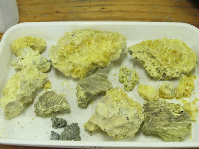
Sulfur!!! The ones with the ripples are from the top of the molten sulfur lake, the large ones on top have some nice crystals, and the tiny grayish ones on bottom are the spherules

Sulfur!!! The ones with the ripples are from the top of the molten sulfur lake, the large ones on top have some nice crystals, and the tiny grayish ones on bottom are the spherules

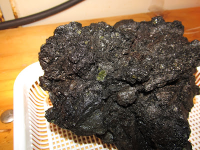
A relatively fresh piece of boninite with a nice big clinopyroxene crystal in the middle.
Subscribe to:
Posts (Atom)